tharr she blows...
View san francisco skate spot map in a larger map
this is my updated skatemap, which is now starting to map the entire city, not just SFSU. There is now an expanded picture section also. Im also including skate-friendly business and hang outs.
Tuesday, May 19, 2009
Monday, May 18, 2009
project!
For my final project I've decided to continue on with my skate map. I will display the map, and then give a brief summary of what I've changed and what I'll continue to change.
Wednesday, May 13, 2009
makin' that paper, son! (draft 1)
John Rasmussen
5/12/08
Locaive media
A reflection on a semester of locative Media
This semester has shown me a lot about something I had previously no idea about, locative media. Before taking this class I had little to no experience in any sort of conceptual or technological arts. Thanks to this class I’ve gotten to dive head-long in to this new art form, by learning about different locative pieces, like MILK or .walk, and by actually constructing my own pieces using tools we’ve discussed in class. I’ve also learned a lot about where locative media came from, and hopefully where it’s going.
I started this semester having no idea that there was a 5th floor let alone a whole Conceptual arts department. That being said, it’s no surprise that I was completely ignorant to the world of locative media, even though I had dealt with it directly and indirectly several times. This semester opened my eyes up to not only the concept of locative media, but how maps define the space around us, and how locative media can help shift and redefine this areas. One of the most striking things I read in the begging of the semester was an article entitled “Beyond Locative Media” by Marc Tuters and Kazys Varnelis, which introduced the topic of locative media and its history as an art. There was one part that stuck out to me concerning the target audience, “unlike net art, produced by a priestly technological class for an elite arts audience, locative media strives, at least rhetorically, to reach a mass audience by attempting to engage consumer technologies, and redirect their power”. This spoke to me, and this is what really got my attention. The ability to not only reach normal people, who may have no idea what the term locative media even means, but to gain their attention and even change the way they relate to the world spatially. I experienced this first hand when we went to the Go Car trip. Although I had encountered GPS devices and used them, I had never used one quite like that. That trip really helped me see the possible extensions and applications of locative technology. Another resource from class, which extended my understanding of locative media’s applications, was the OpenMapping project. The OpenMapping project showed me how one can redefine space to fit the changing needs of society. That is to say, that one can shift the meaning or purpose of a place simply by redefining it on a map. This also changed the way I looked at maps, because it showed me that the people who make maps control the way we perceive the space they are defining. Another section of the reading that I found interesting and also really covered the topic of mapping and its designation of power was in the HeadMap manifesto,
“Control of land and freedom of movement are traditional measures of spatial power. Countries, borders, razor wire, checkpoints, property and prisons all reflect on how the space is subdivided and owned and how people are contained and controlled.”
The Headmap manifesto was the best reading of the semester, in my opinion, because it showed the far-reaching implications of defining space. That space, when defined, is ultimately controlled by those who define it, and if we accept those definitions we are essentially controlled by the people who made them. This really influenced my first project in the class, because I had had problems with this very situation. I had a run in with the police concerning where I could and couldn’t ride my skateboard, which ended up costing me about 100 dollars. After this, I realized it was the police an administration which had defined this area as anti-skateboarding, which is why I sought to re-define the areas around campus as skateboard friendly by making a map of all the good skate spots around campus.
I’ve also learned about the relationship’s that can be made with maps, and how interconnected people are despite geographical separations. The subject of “the Wall”, the separating wall which runs across parts of Palestine, really showed me the reality of the situation there by applying it to the place in which I live. By placing the wall over the city and overlaying the various encampments and neighborhoods, I was able to see where I could and couldn’t go, where I could shop or ride my bike, even which friends I probably couldn’t see any more. This juxtaposition of the two maps caused me to realize that peoples lives are dramatically changed when their space is defined so rigidly. I think this is one of locative medias strong points, its ability to relate 2 completely different environments and draw strong similarities so that people from those places might find they had more in common then they thought before. It essentially has the power to put you in another persons “shoes”, or environment, while remaining in your own, which allows you to see the similarities and provide an unmatched feeling connectedness.
This semester showed me a lot about the possibilities of redefining space, from reading about the enslavement of our world by the Cartesian coordinate system to actually constructing my own m-scape. It taught me that space is constantly being redefined, and that the best ting you can do is define your own space, rather then let someone else define it for you. It showed me that there is no longer a frontier on land, but within cyberspace. Most importantly, it has shown me that humans share a common bond, despite religious or geographic or national designation.
Thursday, April 30, 2009
a little about m scape and some more about the wall
so, the m scape project worked surprisingly well. For my project I decided to edit some of my favorite songs and place them around campus to create different moods as you walked around the center of campus. I was really surprised at how easy everything came together within the editing program. I was also really happy that my device and the gps decided to work well in both the testing before class and the during the actual trials. I only got to do one other m-scape besides my own, which was robs. His walk consisted of random sentences read aloud, usually consisting of some funny wording. The thing i really liked about it was that as the sentences were played to me over the headphones, my mind would wander off on a random tangent due to how peculiar the sentences were.
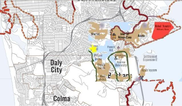
Also, I think I'm going to continue working on the idea of the wall within San Francisco for my final project. more specifically, how my area and all the things I do (like going to school) would be affected. Right now I'm researching ramat sholomo, a Israeli neighborhood which falls directly on the area which I live.
"JERUSALEM - MARCH 12: (FILE PHOTO) The ultra-Orthodox Jewish neighborhood of Ramat Shlomo, the latest Israeli development on land it captured from Jordan in the 1967 Six Day War, is seen in this March 12, 2008 aerial view in East Jerusalem."


the weirdest thing about that picture is that my neighborhood is also built into a hillside, so they look startlingly similar.
lastly, an interesting article about the wall and ramat shlomo-nian's
Also, I think I'm going to continue working on the idea of the wall within San Francisco for my final project. more specifically, how my area and all the things I do (like going to school) would be affected. Right now I'm researching ramat sholomo, a Israeli neighborhood which falls directly on the area which I live.
"JERUSALEM - MARCH 12: (FILE PHOTO) The ultra-Orthodox Jewish neighborhood of Ramat Shlomo, the latest Israeli development on land it captured from Jordan in the 1967 Six Day War, is seen in this March 12, 2008 aerial view in East Jerusalem."
the weirdest thing about that picture is that my neighborhood is also built into a hillside, so they look startlingly similar.
lastly, an interesting article about the wall and ramat shlomo-nian's
Tuesday, April 7, 2009
even better
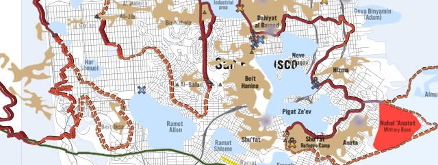
this version of my map is much better then the last, it clearly displays the areas around my house affected by the wall/neighborhood implementation. the weirdest thing about this is how congruent the wall is to the pre-existing communal divides.

Monday, April 6, 2009
gettin' overlayed
So, I used super advanced MS pain technology to overlay the map of the Israeli and Palestinian neighborhoods on where I live

Thursday, March 12, 2009
know your place...
This article was awesome because it really introduced a lot of the questions I had when I looked at the Head Map Manifesto originally, and broke down a lot of key elements into more understandable points. However, I do still have questions left unanswered.
I had originally launched into the headmap manifesto unaware of the "know your place" article, and while it was really interesting, it also left me with several questions about the logistics and realities of having such a system. As I read the "Know Your Place" article, I was surprised at how similar my questions were to that of the authors, for example, I immediately thought of how much of the internet is a festering cesspool of advertisements, shopping, and pornography, or "utter dross, and often offensive, nasty dross at that". But, how much of out world doesn't reflect those properties? Downtown, the dated equivalent to the internet, is exactly the same, a festering cesspool of advertisements, shopping, and pornography. But just as we filter these things out in our daily lives, certain filters will be imposed to help get thin out the rubbish. Also, the idea of using the friend of a friend system is a bit limiting, however I feel that rather then creating cliques, this would encourage a more all-inclusive look at who is in your circle of friends.
One questions I was left with after reading was how is one going to apply the headmap to a rural setting? sure, free wirless internet seems feesable to those who live in metropolitian cities, but what about jungles, or forests?
"the police and the other symbols of structure and power, to the mundane and banal buildings they see around them, all project an image of permanence and stability."
...to be continued later...
Tuesday, March 10, 2009
sf state skate maps
so, for my project I decided to put together a map of all the skate spots in and around SF state. I often find myself stuck at school for hours on end, so I go skating on my breaks to get a little physical activity in between all the sitting. I made this map in hopes that everyone goes skating on their breaks to help remove the stigma away from skateboarding on campus. It worked for bikes,
right?
Anyways, I made the map in google maps. I'm hoping to add as many skatespots in San Francisco as possible, so if you have some information or pictures, that'd be totally radical if you sent them my way.
View Larger Map
right?
Anyways, I made the map in google maps. I'm hoping to add as many skatespots in San Francisco as possible, so if you have some information or pictures, that'd be totally radical if you sent them my way.
View Larger Map
Wednesday, March 4, 2009
ins and outs of using a gps device...
well, I'd have to say that learning to use the GPS device was certainly an experience. Although I had previously used a Garmin Gps device, it was a newer model with a much simpler way of converting tracks to the computer. However for this exercise I used an older model which presented me with a couple of problems. First, it had problems getting reception and when it did my accuracy was off to the tune of about 52-70feet. I think this may have been due to the heavy could cover from the crazy rain storms that happened on Monday night when I was doing my actual tracks and waypoints. The second problem was the computer interface, which took forever to finally figure out because of the VGA port. It worked in the end, however my data was severely off. It did have a few of the waypoints, however they were in some weird land mass.
Tuesday, February 17, 2009
Go cars/ Open mapping
The field trip that we took in the Go Cars on Thursday, February 12th, was a really good way to see the commercial appeal of locative media. I've used gps devices in cars and I've been on mapped tours, and I'd have to say this combines the best of both. Although there was no visual reference for the directions played over the speakers, they were often simple enough that they could be remembered until the next set of directions were recieved. Only once did we vere off course, and even then we were able to make it back to the designated path. The way the diretions were delievered were also pretty awesome, because they had alternate routes and stuff which allowed you to go do something like go to a senic view, and then return to the path. I wish I had brought several more layers and that my pants hadn't ripped, but other then that it was fantastic. I had fun and was humiliated simultaiounsly.
the open mapping tutorial video was pretty well done, however its a little long and included some things I don't think I'm ever gonna use. I was really interested in the open map software by Cloud Made, specifically the way to custmize the way the map looks. I really hope we get to use some of this stuff.
the open mapping tutorial video was pretty well done, however its a little long and included some things I don't think I'm ever gonna use. I was really interested in the open map software by Cloud Made, specifically the way to custmize the way the map looks. I really hope we get to use some of this stuff.
Tuesday, February 10, 2009
geolocation technologies
I found these articles to be really interesting because they showed me exactly how GPS works down to the slightest detail, but more importantly they gave me a logical connection between certain inventions and practices I already knew about. specifically, the relationship between GPS and the practice of measuring speed at sea using a small hourglass and rope.
Something else I found really to be almost jaw dropping is the amound of junk that is shot into space. I wonder how many of these satelites can be used for GPS and other spacial mapping programs to deliver more accurate data and even real time scanning
Something else I found really to be almost jaw dropping is the amound of junk that is shot into space. I wonder how many of these satelites can be used for GPS and other spacial mapping programs to deliver more accurate data and even real time scanning
Wednesday, February 4, 2009
Beyond locative media
I found this article to be very insightful as to directing me towards what locative media actually is. Since this is my first encounter with locative media, and conceptual art in general, I thought this article contained many key ideas to both unfamiliar subjects. Two of the most important points of this article were the key differences between Net art and locative media, and the description the invisible and often imperceptible network that locative media is based in. These two points were important because they outlined both what locative media is and how it works.
One point that came to mind as I read the article concerned the complaints concerning boundaries, since the most (if not all) locative media pieces are based in the cartesian coordinate system many critics argue against the legitmacy of locative meida as an art, stating that "art as autonomous from the circuits of mass communication technologies". Critics also argue that locative meida does nothing more than create a "hyper-rationalist grid of Imperial infrastructure.", however I feel that these ideas, as the article also stated, are incorrect. I feel that with the onset of mass communication and networking sparked by locative meida, it will shift the control of such systems from the larger power structure to the general populus. Locative media is less of a cage and more of a means to deeper understand human connections and expierences across geographic boundries both natural and man-made.
One point that came to mind as I read the article concerned the complaints concerning boundaries, since the most (if not all) locative media pieces are based in the cartesian coordinate system many critics argue against the legitmacy of locative meida as an art, stating that "art as autonomous from the circuits of mass communication technologies". Critics also argue that locative meida does nothing more than create a "hyper-rationalist grid of Imperial infrastructure.", however I feel that these ideas, as the article also stated, are incorrect. I feel that with the onset of mass communication and networking sparked by locative meida, it will shift the control of such systems from the larger power structure to the general populus. Locative media is less of a cage and more of a means to deeper understand human connections and expierences across geographic boundries both natural and man-made.
Subscribe to:
Posts (Atom)
